IDENTITEETTIKRIISI: ISRAELIN HENKILÖTIETOJÄRJESTELMÄ
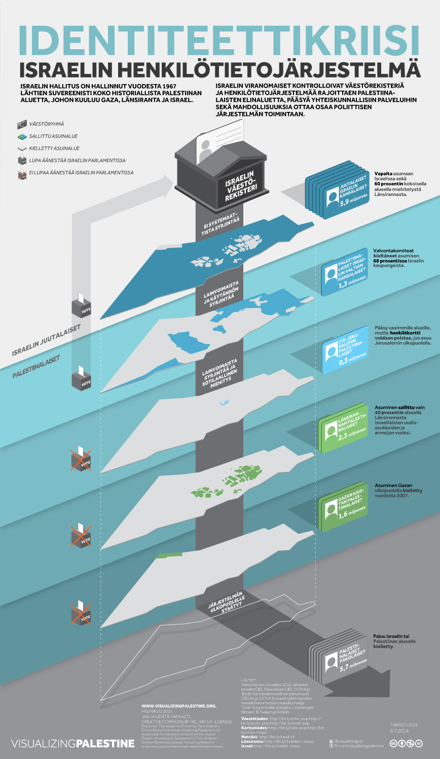
[May 2014] May 15th, 2014, was the 66th anniversary of the Nakba ("catastrophe"), referring to the ethnic cleansing of 750,000 Palestinians from their homeland during events leading up to the creation of the State of Israel. Today, the fragmentation of the Palestinian people both inside and outside of historic Palestine remains as concrete as ever. ‘Identity Crisis’ shows how different population groups fall under de-facto Israeli sovereignty today and de-constructs how they are segregated and fragmented based on the system of colored ID cards all controlled by the Israeli Ministry of Interior.
Sources & Data
Population estimates for 2011 collated from Israeli CBS, Palestinian CBS, OCHA and Badil. Maps are illustrative, based on data collated from Israel CBS and OCHA.
ID matrix adapted from Helga Tawil-Souri. Additional facts from B’Tselem and Adalah.
Population Data
Central Bureau of Statistics, 2012. Statistical Abstract of Israel (accessed on 15 May 2014)
Palestinian Central Bureau of Statistics, Estimated Population in the Palestinian Territory Mid-Year by Governorate,1997-2016 (accessed on 15 May 2014)
Badil, 2012. Survey of Palestinian Refugees and Internally Displaced Persons 2010 – 2012 (PDF)
Map Data
Central Bureau of Statistics, 2012. Statistical Abstract of Israel. (accessed on 15 May 2014)
OCHA, 2012. Humanitarian Atlas, December 2012 (accessed on 15 May 2014)
WB Areas
B'Tselem, 2013. What is Area C? (accessed on 15 May 2014)
Israel Admissions
Adalah, 2011. Adalah NGO Report to the UN Committee on Economic, Social and Cultural Rights: Arab Palestinian Citizens of Israel (PDF)
RELATED VISUALS
MITÄ LAKI SANOO MUURISTA
CONTRIBUTE
Help us continue to create free and accessible visual resources for the Palestinian solidarity movement.
